
Make a donation
Gear up for your next adventure:
As an Amazon Associate, this site earns from qualifying purchases at no extra cost to you.
Hoher Ifen topographic map
Click on the map to display elevation.
Make a donation
Gear up for your next adventure:
As an Amazon Associate, this site earns from qualifying purchases at no extra cost to you.
Hoher Ifen
Nordöstlich des Ifenplateaus befindet sich das Gottesackerplateau, eine unter Naturschutz stehende Karstlandschaft mit zahlreichen Höhlen und seltenen Gebirgspflanzen. Die bedeutendsten Höhlen sind das Hölloch im Mahdtal und die Schneckenlochhöhle bei Schönenbach. Am östlichen Abhang des Bergstocks wurde 1998 auf der Schneiderkürenalpe in etwa 1500 m Höhe vom Amateurarchäologen Detlef Willand eine steinzeitliche Wohnstätte entdeckt und mit fachlicher Begleitung durch die Universität Innsbruck freigelegt.
Make a donation
Gear up for your next adventure:
As an Amazon Associate, this site earns from qualifying purchases at no extra cost to you.
About this map
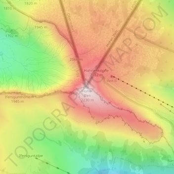
Name: Hoher Ifen topographic map, elevation, terrain.
Location: Hoher Ifen, Egg, Bezirk Bregenz, Vorarlberg, Österreich (47.35463 10.10016 47.35473 10.10026)
Average elevation: 1,826 m
Minimum elevation: 1,388 m
Maximum elevation: 2,205 m
Make a donation
Gear up for your next adventure:
As an Amazon Associate, this site earns from qualifying purchases at no extra cost to you.