
Thank you for supporting this site ❤️
Make a donation
Make a donation
Gear up for your next adventure:
As an Amazon Associate, this site earns from qualifying purchases at no extra cost to you.
Keuling topographic map
Click on the map to display elevation.
Thank you for supporting this site ❤️
Make a donation
Make a donation
Gear up for your next adventure:
As an Amazon Associate, this site earns from qualifying purchases at no extra cost to you.
About this map
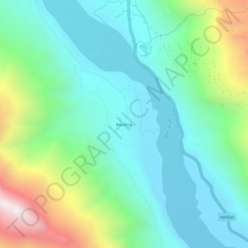
Name: Keuling topographic map, elevation, terrain.
Location: Keuling, Kaza, Spiti, Lahul and Spiti, Himachal Pradesh, India (32.17928 78.05526 32.21928 78.09526)
Average elevation: 3,867 m
Minimum elevation: 3,526 m
Maximum elevation: 4,820 m
Thank you for supporting this site ❤️
Make a donation
Make a donation
Gear up for your next adventure:
As an Amazon Associate, this site earns from qualifying purchases at no extra cost to you.