
Attenberg topographic map
Interactive map
Click on the map to display elevation.
About this map
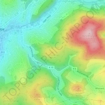
Name: Attenberg topographic map, elevation, terrain.
Average elevation: 395 m
Minimum elevation: 313 m
Maximum elevation: 530 m
Other topographic maps
Click on a map to view its topography, its elevation and its terrain.
Neuenkleusheim
Deutschland > Nordrhein-Westfalen > Kreis Olpe > Olpe
Neuenkleusheim, Olpe, Kreis Olpe, Nordrhein-Westfalen, Deutschland
Average elevation: 447 m
Friedrichsthal
Deutschland > Nordrhein-Westfalen > Kreis Olpe > Olpe
Friedrichsthal, Olpe, Kreis Olpe, Nordrhein-Westfalen, 57462, Deutschland
Average elevation: 389 m
Rhode
Deutschland > Nordrhein-Westfalen > Kreis Olpe > Olpe
Rhode, Olpe, Kreis Olpe, Nordrhein-Westfalen, 57462, Deutschland
Average elevation: 372 m
Schlammborn
Deutschland > Nordrhein-Westfalen > Kreis Olpe > Olpe
Schlammborn, Olpe, Kreis Olpe, Nordrhein-Westfalen, 57462, Deutschland
Average elevation: 394 m
Rüblinghausen
Deutschland > Nordrhein-Westfalen > Kreis Olpe > Olpe
Rüblinghausen, Olpe, Kreis Olpe, Nordrhein-Westfalen, 57462, Deutschland
Average elevation: 371 m
Nocken
Deutschland > Nordrhein-Westfalen > Kreis Olpe > Olpe
Nocken, Olpe, Kreis Olpe, Nordrhein-Westfalen, 57462, Deutschland
Average elevation: 435 m
Fahlenscheid
Deutschland > Nordrhein-Westfalen > Kreis Olpe > Olpe
Fahlenscheid, Olpe, Kreis Olpe, Nordrhein-Westfalen, Deutschland
Average elevation: 497 m
Altenkleusheim
Deutschland > Nordrhein-Westfalen > Kreis Olpe > Olpe
Altenkleusheim, Olpe, Kreis Olpe, Nordrhein-Westfalen, Deutschland
Average elevation: 441 m
Höchsten
Deutschland > Nordrhein-Westfalen > Kreis Olpe > Olpe
Höchsten, Olpe, Kreis Olpe, Nordrhein-Westfalen, 57462, Deutschland
Average elevation: 431 m