
Make a donation
Gear up for your next adventure:
As an Amazon Associate, this site earns from qualifying purchases at no extra cost to you.
Secunda topographic map
Click on the map to display elevation.
Make a donation
Gear up for your next adventure:
As an Amazon Associate, this site earns from qualifying purchases at no extra cost to you.
Secunda
Secunda is located at approximately 26°S latitude and 29°E longitude, at an elevation of 1,620 metres above sea level. It lies 180 kilometres from Pretoria, 135 kilometres from Johannesburg, 100 kilometres from Brakpan, 250 kilometres from Potchefstroom, 530 kilometres from Durban, and 1,530 kilometres from Cape Town.
Make a donation
Gear up for your next adventure:
As an Amazon Associate, this site earns from qualifying purchases at no extra cost to you.
About this map
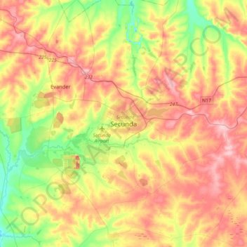
Name: Secunda topographic map, elevation, terrain.
Average elevation: 1,619 m
Minimum elevation: 1,544 m
Maximum elevation: 1,694 m
Make a donation
Gear up for your next adventure:
As an Amazon Associate, this site earns from qualifying purchases at no extra cost to you.
Other topographic maps
Click on a map to view its topography, its elevation and its terrain.
Heyshope Dam
South Africa > Mpumalanga > Gert Sibande > Mkhondo Local Municipality
Average elevation: 1,325 m
Vygeboom Dam
South Africa > Mpumalanga > Gert Sibande > Albert Luthuli Local Municipality
Average elevation: 1,056 m
Make a donation
Gear up for your next adventure:
As an Amazon Associate, this site earns from qualifying purchases at no extra cost to you.
Dipaleseng Ward 2
South Africa > Mpumalanga > Gert Sibande > Dipaleseng Local Municipality
Average elevation: 1,637 m
Grootdraai Dam
South Africa > Mpumalanga > Gert Sibande > Lekwa Local Municipality
Average elevation: 1,549 m
Make a donation
Gear up for your next adventure:
As an Amazon Associate, this site earns from qualifying purchases at no extra cost to you.
Make a donation
Gear up for your next adventure:
As an Amazon Associate, this site earns from qualifying purchases at no extra cost to you.
Mpuluzi
South Africa > Mpumalanga > Gert Sibande > Albert Luthuli Local Municipality
Average elevation: 1,458 m
Mpuluzi
South Africa > Mpumalanga > Gert Sibande > Albert Luthuli Local Municipality
Average elevation: 1,458 m
Make a donation
Gear up for your next adventure:
As an Amazon Associate, this site earns from qualifying purchases at no extra cost to you.
Heyshope Dam
South Africa > Mpumalanga > Gert Sibande > Mkhondo Local Municipality
Average elevation: 1,325 m
Make a donation
Gear up for your next adventure:
As an Amazon Associate, this site earns from qualifying purchases at no extra cost to you.
Grootdraai Dam
South Africa > Mpumalanga > Gert Sibande > Lekwa Local Municipality
Average elevation: 1,549 m
Make a donation
Gear up for your next adventure:
As an Amazon Associate, this site earns from qualifying purchases at no extra cost to you.
Blesbokspruit
South Africa > Mpumalanga > Gert Sibande > Lekwa Local Municipality
Average elevation: 1,606 m
Make a donation
Gear up for your next adventure:
As an Amazon Associate, this site earns from qualifying purchases at no extra cost to you.