
Badminton topographic map
Interactive map
Click on the map to display elevation.
About this map
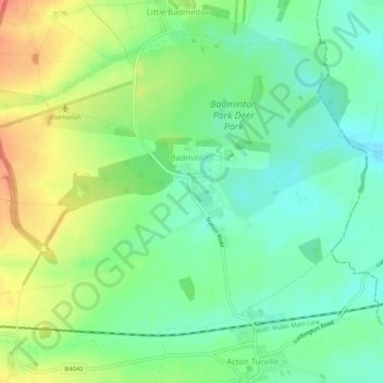
Name: Badminton topographic map, elevation, terrain.
Average elevation: 133 m
Minimum elevation: 109 m
Maximum elevation: 170 m
Other topographic maps
Click on a map to view its topography, its elevation and its terrain.
Warmley
United Kingdom > England > South Gloucestershire
Warmley, Siston, South Gloucestershire, West of England, England, BS15 4PP, United Kingdom
Average elevation: 69 m
Hanham
United Kingdom > England > South Gloucestershire
Hanham, South Gloucestershire, West of England, England, United Kingdom
Average elevation: 71 m
Goblin Ledge
United Kingdom > England > South Gloucestershire > Severn Beach > New Passage
Goblin Ledge, Prince of Wales Bridge, New Passage, Pilning and Severn Beach, Severn Beach, South Gloucestershire, West of England, England, BS35 4NQ, United Kingdom
Average elevation: 2 m
Olveston
United Kingdom > England > South Gloucestershire
Olveston, South Gloucestershire, West of England, England, United Kingdom
Average elevation: 31 m
Buckover
United Kingdom > England > South Gloucestershire > Thornbury > Milbury Heath
Buckover, Milbury Heath, Thornbury, South Gloucestershire, West of England, England, GL12 8DX, United Kingdom
Average elevation: 65 m
Ridge Wood
United Kingdom > England > South Gloucestershire > Yate
Ridge Wood, Ladden Garden Village, Yate, South Gloucestershire, West of England, England, United Kingdom
Average elevation: 90 m
Hill
United Kingdom > England > South Gloucestershire > Hill
Hill, South Gloucestershire, West of England, England, United Kingdom
Average elevation: 13 m
New Passage
United Kingdom > England > South Gloucestershire > Redwick
New Passage, Pilning and Severn Beach, Redwick, South Gloucestershire, West of England, England, BS35 4NG, United Kingdom
Average elevation: 3 m
Tytherington
United Kingdom > England > South Gloucestershire
Tytherington, South Gloucestershire, West of England, England, United Kingdom
Average elevation: 68 m
Siston
United Kingdom > England > South Gloucestershire
Siston, South Gloucestershire, West of England, England, United Kingdom
Average elevation: 80 m
Yate
United Kingdom > England > South Gloucestershire
Yate, South Gloucestershire, West of England, England, United Kingdom
Average elevation: 83 m
Little Bristol
United Kingdom > England > South Gloucestershire > Charfield
Little Bristol, Charfield, South Gloucestershire, West of England, England, GL12 8LN, United Kingdom
Average elevation: 57 m
Bradley Stoke
United Kingdom > England > South Gloucestershire
Bradley Stoke, South Gloucestershire, South West England, England, United Kingdom
Average elevation: 62 m
Frampton Cotterell
United Kingdom > England > South Gloucestershire
Frampton Cotterell, South Gloucestershire, South West England, England, United Kingdom
Average elevation: 58 m
Acton Turville
United Kingdom > England > South Gloucestershire > Acton Turville
Acton Turville, South Gloucestershire, South West England, England, United Kingdom
Average elevation: 130 m
Chipping Sodbury
United Kingdom > England > South Gloucestershire
Chipping Sodbury, South Gloucestershire, West of England, England, BS37 6AD, United Kingdom
Average elevation: 108 m
Hallen
United Kingdom > England > South Gloucestershire
Hallen, South Gloucestershire, West of England, England, BS10 7RP, United Kingdom
Average elevation: 26 m
Easter Compton
United Kingdom > England > South Gloucestershire
Easter Compton, South Gloucestershire, West of England, England, BS35 5SD, United Kingdom
Average elevation: 27 m
Kingswood
United Kingdom > England > South Gloucestershire
Kingswood, South Gloucestershire, West of England, England, BS15 8LQ, United Kingdom
Average elevation: 57 m