
Make a donation
Gear up for your next adventure:
As an Amazon Associate, this site earns from qualifying purchases at no extra cost to you.
Hasenhorn topographic map
Click on the map to display elevation.
Make a donation
Gear up for your next adventure:
As an Amazon Associate, this site earns from qualifying purchases at no extra cost to you.
Hasenhorn
Im Jahr 2004 wurde die ursprüngliche Einer-Sesselbahn am Hasenhorn entfernt und durch die Doppel-Sesselbahn Hasenhornbahn ersetzt. Der Doppelsessellift ist 964 Meter lang. Die Bergstation steht 520 m nordwestlich des Berggipfels auf 1026 m und die am Ortsrand von Todtnau gelegene Talstation auf 662,45 m Höhe; somit ergeben sich 363,55 m Höhendifferenz. Eine Liftfahrt dauert in einer Richtung 13,14 Minuten. Der Lift hat 89 Sessel, kann also maximal 178 Personen fassen. Die maximale Förderleistung beträgt bis zu etwa 602 Personen pro Stunde (Bergfahrten). Die reguläre Fahrtgeschwindigkeit beträgt 1,2 m/s und kann bis zu 1,8 m/s gesteigert werden. Jeweils zwischen zwei Sesseln ist ein Lastengehänge angebracht, an dem Rodelschlitten und Mountainbikes sowie sonstige Lasten transportiert werden können (Rucksäcke, Gleitschirme, Kinderwagen usw.). Kapazität: Bis zu 200 Schlitten pro Stunde.[3]
Make a donation
Gear up for your next adventure:
As an Amazon Associate, this site earns from qualifying purchases at no extra cost to you.
About this map
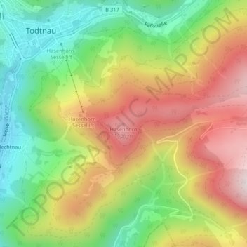
Name: Hasenhorn topographic map, elevation, terrain.
Average elevation: 890 m
Minimum elevation: 612 m
Maximum elevation: 1,209 m
Make a donation
Gear up for your next adventure:
As an Amazon Associate, this site earns from qualifying purchases at no extra cost to you.
Other topographic maps
Click on a map to view its topography, its elevation and its terrain.
Todtnauberg
Deutschland > Baden-Württemberg > Landkreis Lörrach > Todtnau
Der Todtnauberger Wasserfall ist mit 97 Metern Fallhöhe in fünf Fallstufen einer der höchsten Wasserfälle Deutschlands.
Average elevation: 1,117 m