
Make a donation
Gear up for your next adventure:
As an Amazon Associate, this site earns from qualifying purchases at no extra cost to you.
Milla Verde topographic map
Click on the map to display elevation.
Make a donation
Gear up for your next adventure:
As an Amazon Associate, this site earns from qualifying purchases at no extra cost to you.
About this map
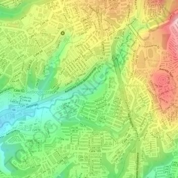
Name: Milla Verde topographic map, elevation, terrain.
Average elevation: 913 m
Minimum elevation: 799 m
Maximum elevation: 1,032 m
Make a donation
Gear up for your next adventure:
As an Amazon Associate, this site earns from qualifying purchases at no extra cost to you.
Other topographic maps
Click on a map to view its topography, its elevation and its terrain.
Comuna 5 - García Rovira
Colombia > Santander > Bucaramanga > Perímetro Urbano Bucaramanga
Average elevation: 851 m
Comuna 10 - Provenza
Colombia > Santander > Bucaramanga > Perímetro Urbano Bucaramanga
Average elevation: 883 m
Comuna 10 - Provenza
Colombia > Santander > Bucaramanga > Perímetro Urbano Bucaramanga
Average elevation: 883 m