
Gütersloh topographic map
Interactive map
Click on the map to display elevation.
About this map
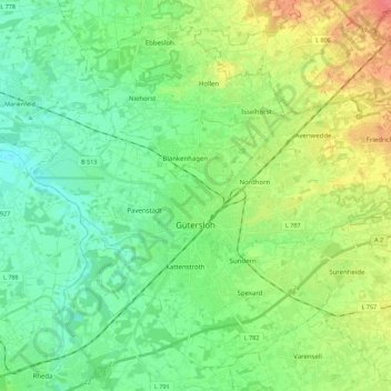
Name: Gütersloh topographic map, elevation, terrain.
Location: Gütersloh, Kreis Gütersloh, Noordrijn-Westfalen, Duitsland (51.85597 8.28400 51.97709 8.50599)
Average elevation: 80 m
Minimum elevation: 61 m
Maximum elevation: 119 m
Other topographic maps
Click on a map to view its topography, its elevation and its terrain.
Stukenbrock
Duitsland > Noordrijn-Westfalen > Kreis Gütersloh > Schloß Holte-Stukenbrock
Stukenbrock, Schloß Holte-Stukenbrock, Kreis Gütersloh, Noordrijn-Westfalen, 33758, Duitsland
Average elevation: 135 m
Teutoburger Wald
Duitsland > Noordrijn-Westfalen > Kreis Gütersloh
Teutoburger Wald, Kreis Gütersloh, Noordrijn-Westfalen, Duitsland
Average elevation: 105 m
Halle (Westf.)
Duitsland > Noordrijn-Westfalen > Kreis Gütersloh
Halle (Westf.), Kreis Gütersloh, Noordrijn-Westfalen, 33790, Duitsland
Average elevation: 125 m
Rietberg
Duitsland > Noordrijn-Westfalen > Kreis Gütersloh > Rietberg > Rietberg
Rietberg, Kreis Gütersloh, Noordrijn-Westfalen, 33397, Duitsland
Average elevation: 80 m