
Make a donation
Gear up for your next adventure:
As an Amazon Associate, this site earns from qualifying purchases at no extra cost to you.
Affleck Lake topographic map
Click on the map to display elevation.
Make a donation
Gear up for your next adventure:
As an Amazon Associate, this site earns from qualifying purchases at no extra cost to you.
About this map
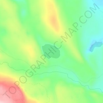
Name: Affleck Lake topographic map, elevation, terrain.
Average elevation: 417 m
Minimum elevation: 337 m
Maximum elevation: 544 m
Make a donation
Gear up for your next adventure:
As an Amazon Associate, this site earns from qualifying purchases at no extra cost to you.
Other topographic maps
Click on a map to view its topography, its elevation and its terrain.
Hazelton Mountains
Canada > British Columbia > Regional District of Kitimat-Stikine > Area B (Suskwa/Kitwanga/Kispiox)
Average elevation: 1,117 m
Swan Lake
Canada > British Columbia > Regional District of Kitimat-Stikine > Area B (Suskwa/Kitwanga/Kispiox)
Average elevation: 540 m
South Hazelton
Canada > British Columbia > Regional District of Kitimat-Stikine > Area B (Suskwa/Kitwanga/Kispiox) > South Hazelton
Average elevation: 278 m
Hagwilget
Canada > British Columbia > Regional District of Kitimat-Stikine > Area B (Suskwa/Kitwanga/Kispiox)
Average elevation: 337 m
Make a donation
Gear up for your next adventure:
As an Amazon Associate, this site earns from qualifying purchases at no extra cost to you.
Kitwanga
Canada > British Columbia > Regional District of Kitimat-Stikine > Area B (Suskwa/Kitwanga/Kispiox) > Kitwanga
Average elevation: 329 m
Hagwilget
Canada > British Columbia > Regional District of Kitimat-Stikine > Area B (Suskwa/Kitwanga/Kispiox)
Average elevation: 337 m