
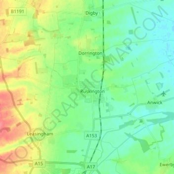
Ruskington topographic map
Interactive map
Click on the map to display elevation.
About this map
Name: Ruskington topographic map, elevation, terrain.
Average elevation: 18 m
Minimum elevation: 0 m
Maximum elevation: 55 m
Other topographic maps
Click on a map to view its topography, its elevation and its terrain.
North Hykeham
United Kingdom > England > Lincolnshire > North Kesteven
North Hykeham, North Kesteven, Lincolnshire, England, United Kingdom
Average elevation: 12 m
Heighington
United Kingdom > England > Lincolnshire > North Kesteven > Heighington
Heighington, North Kesteven, Lincolnshire, England, United Kingdom
Average elevation: 20 m