
Thank you for supporting this site ❤️
Make a donation
Make a donation
Gear up for your next adventure:
As an Amazon Associate, this site earns from qualifying purchases at no extra cost to you.
Planoles topographic map
Click on the map to display elevation.
Thank you for supporting this site ❤️
Make a donation
Make a donation
Gear up for your next adventure:
As an Amazon Associate, this site earns from qualifying purchases at no extra cost to you.
About this map
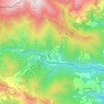
Name: Planoles topographic map, elevation, terrain.
Location: Planoles, Ripollés, Gerona, Cataluña, 17535, España (42.28243 2.08076 42.36370 2.12967)
Average elevation: 1,601 m
Minimum elevation: 910 m
Maximum elevation: 2,549 m
Thank you for supporting this site ❤️
Make a donation
Make a donation
Gear up for your next adventure:
As an Amazon Associate, this site earns from qualifying purchases at no extra cost to you.
Other topographic maps
Click on a map to view its topography, its elevation and its terrain.
Sant Pau de Segúries
España > Cataluña > Ripollés > Sant Pau de Segúries > Sant Pau de Segúries
Average elevation: 962 m