
Thank you for supporting this site ❤️
Make a donation
Make a donation
Gear up for your next adventure:
As an Amazon Associate, this site earns from qualifying purchases at no extra cost to you.
Tellego topographic map
Click on the map to display elevation.
Thank you for supporting this site ❤️
Make a donation
Make a donation
Gear up for your next adventure:
As an Amazon Associate, this site earns from qualifying purchases at no extra cost to you.
About this map
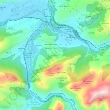
Name: Tellego topographic map, elevation, terrain.
Location: Tellego, Soto Ribera, Ribera de Arriba, Asturias, 33173, Spain (43.27873 -5.88748 43.31873 -5.84748)
Average elevation: 257 m
Minimum elevation: 112 m
Maximum elevation: 625 m
Thank you for supporting this site ❤️
Make a donation
Make a donation
Gear up for your next adventure:
As an Amazon Associate, this site earns from qualifying purchases at no extra cost to you.