
Thank you for supporting this site ❤️
Make a donation
Make a donation
Gear up for your next adventure:
As an Amazon Associate, this site earns from qualifying purchases at no extra cost to you.
Fresnillo topographic map
Click on the map to display elevation.
Thank you for supporting this site ❤️
Make a donation
Make a donation
Gear up for your next adventure:
As an Amazon Associate, this site earns from qualifying purchases at no extra cost to you.
About this map
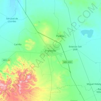
Name: Fresnillo topographic map, elevation, terrain.
Location: Fresnillo, Zacatecas, 99000, Mexico (23.02113 -103.03291 23.34113 -102.71291)
Average elevation: 2,187 m
Minimum elevation: 2,031 m
Maximum elevation: 2,837 m
Thank you for supporting this site ❤️
Make a donation
Make a donation
Gear up for your next adventure:
As an Amazon Associate, this site earns from qualifying purchases at no extra cost to you.