
Thank you for supporting this site ❤️
Make a donation
Make a donation
Gear up for your next adventure:
As an Amazon Associate, this site earns from qualifying purchases at no extra cost to you.
Choclococha topographic map
Click on the map to display elevation.
Thank you for supporting this site ❤️
Make a donation
Make a donation
Gear up for your next adventure:
As an Amazon Associate, this site earns from qualifying purchases at no extra cost to you.
About this map
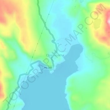
Name: Choclococha topographic map, elevation, terrain.
Location: Choclococha, Santa Ana, Castrovirreyna, Huancavelica, Perú (-13.18031 -75.09159 -13.14031 -75.05159)
Average elevation: 4,599 m
Minimum elevation: 4,511 m
Maximum elevation: 4,840 m
Thank you for supporting this site ❤️
Make a donation
Make a donation
Gear up for your next adventure:
As an Amazon Associate, this site earns from qualifying purchases at no extra cost to you.