Geolocate

Worthing topographic map

Click on the map to display elevation.

About this map

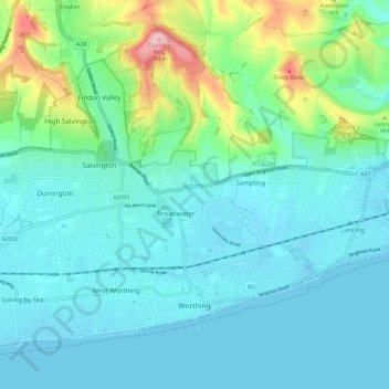
Name: Worthing topographic map, elevation, terrain.

Location: Worthing, West Sussex, England, United Kingdom (50.80174 -0.44656 50.86326 -0.33026)

Average elevation: 35 m

Minimum elevation: -3 m

Maximum elevation: 183 m

Other topographic maps

Click on a map to view its topography, its elevation and its terrain.

Felpham

United Kingdom > England > West Sussex > Arun

Average elevation: 2 m

Shoreham-by-Sea

United Kingdom > England > West Sussex > Adur

Average elevation: 25 m

Gear up for your next adventure:

📡Satellite Messengers - Emergency communication for remote areas without signal
🖊️All-Weather Pens - Pressurized ink cartridges that write upside down and in wet
🧗Rock Climbing Gear - Essentials for the cliffs of Moher or Gap of Dunloe
🧥Gore-Tex Rain Jackets - Breathable and fully waterproof shells for Irish weather
🧴Long-Lasting Sunscreen - Protect against UV rays during long days on the ridges

As an Amazon Associate, this site earns from qualifying purchases at no extra cost to you.