
Belfast topographic map
Interactive map
Click on the map to display elevation.
About this map
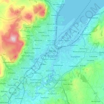
Name: Belfast topographic map, elevation, terrain.
Location: Belfast, County Antrim, Northern Ireland, United Kingdom (54.53061 -6.04548 54.65942 -5.80769)
Average elevation: 92 m
Minimum elevation: -2 m
Maximum elevation: 476 m
Other topographic maps
Click on a map to view its topography, its elevation and its terrain.
Randalstown
United Kingdom > Northern Ireland > County Antrim
Randalstown, County Antrim, Northern Ireland, BT41 3AD, United Kingdom
Average elevation: 57 m
Larne
United Kingdom > Northern Ireland > County Antrim
Larne, County Antrim, Northern Ireland, BT40 1JS, United Kingdom
Average elevation: 54 m
Carrickfergus
United Kingdom > Northern Ireland > County Antrim
Carrickfergus, County Antrim, Ulster, Northern Ireland, BT38 7AF, United Kingdom
Average elevation: 49 m
Antrim
United Kingdom > Northern Ireland > County Antrim > Antrim
Antrim, County Antrim, Northern Ireland, BT41 4AR, United Kingdom
Average elevation: 50 m
Ballymena
United Kingdom > Northern Ireland > County Antrim > Ballymena
Ballymena, County Antrim, Northern Ireland, BT43 6AH, United Kingdom
Average elevation: 74 m
Old Mill
United Kingdom > Northern Ireland > County Antrim > Ballygally > Old Mill
Old Mill, Ballygally, County Antrim, Northern Ireland, BT40 2RX, United Kingdom
Average elevation: 47 m
Bushmills
United Kingdom > Northern Ireland > County Antrim
Bushmills, County Antrim, Ulster, Northern Ireland, BT57 8QB, United Kingdom
Average elevation: 42 m
Lisburn
United Kingdom > Northern Ireland > County Antrim
Lisburn, County Antrim, Northern Ireland, BT28 1BJ, United Kingdom
Average elevation: 92 m