
Make a donation
Gear up for your next adventure:
As an Amazon Associate, this site earns from qualifying purchases at no extra cost to you.
Greater Victoria topographic map
Click on the map to display elevation.
Make a donation
Gear up for your next adventure:
As an Amazon Associate, this site earns from qualifying purchases at no extra cost to you.
About this map
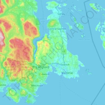
Name: Greater Victoria topographic map, elevation, terrain.
Average elevation: 98 m
Minimum elevation: -1 m
Maximum elevation: 832 m
Make a donation
Gear up for your next adventure:
As an Amazon Associate, this site earns from qualifying purchases at no extra cost to you.
Other topographic maps
Click on a map to view its topography, its elevation and its terrain.
Mary's Peak
Canada > British Columbia > Capital Regional District > Juan de Fuca Electoral Area
Average elevation: 458 m
Mount Erskine
Canada > British Columbia > Capital Regional District > Salt Spring Island Electoral Area
Average elevation: 233 m
Make a donation
Gear up for your next adventure:
As an Amazon Associate, this site earns from qualifying purchases at no extra cost to you.
Shirley
Canada > British Columbia > Capital Regional District > Juan de Fuca Electoral Area > Shirley
Average elevation: 79 m