
Thank you for supporting this site ❤️
Make a donation
Make a donation
Gear up for your next adventure:
As an Amazon Associate, this site earns from qualifying purchases at no extra cost to you.
Fluh topographic map
Click on the map to display elevation.
Thank you for supporting this site ❤️
Make a donation
Make a donation
Gear up for your next adventure:
As an Amazon Associate, this site earns from qualifying purchases at no extra cost to you.
About this map
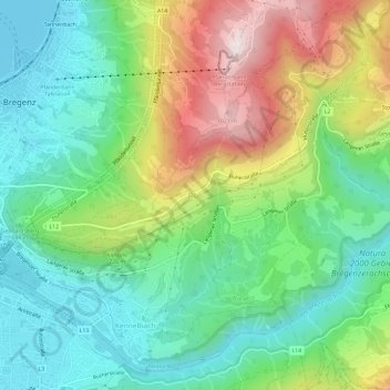
Name: Fluh topographic map, elevation, terrain.
Location: Fluh, Bregenz, Bezirk Bregenz, Vorarlberg, 6921, Österreich (47.47297 9.75401 47.51297 9.79401)
Average elevation: 621 m
Minimum elevation: 393 m
Maximum elevation: 1,055 m
Thank you for supporting this site ❤️
Make a donation
Make a donation
Gear up for your next adventure:
As an Amazon Associate, this site earns from qualifying purchases at no extra cost to you.