
Thank you for supporting this site ❤️
Make a donation
Make a donation
Gear up for your next adventure:
As an Amazon Associate, this site earns from qualifying purchases at no extra cost to you.
Chullo topographic map
Click on the map to display elevation.
Thank you for supporting this site ❤️
Make a donation
Make a donation
Gear up for your next adventure:
As an Amazon Associate, this site earns from qualifying purchases at no extra cost to you.
About this map
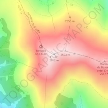
Name: Chullo topographic map, elevation, terrain.
Location: Chullo, Bayárcal, Almeria, Andalusia, Spain (37.09494 -3.00011 37.09504 -3.00001)
Average elevation: 2,302 m
Minimum elevation: 1,898 m
Maximum elevation: 2,606 m
Thank you for supporting this site ❤️
Make a donation
Make a donation
Gear up for your next adventure:
As an Amazon Associate, this site earns from qualifying purchases at no extra cost to you.