
Thank you for supporting this site ❤️
Make a donation
Make a donation
Gear up for your next adventure:
As an Amazon Associate, this site earns from qualifying purchases at no extra cost to you.
Nanren topographic map
Click on the map to display elevation.
Thank you for supporting this site ❤️
Make a donation
Make a donation
Gear up for your next adventure:
As an Amazon Associate, this site earns from qualifying purchases at no extra cost to you.
About this map
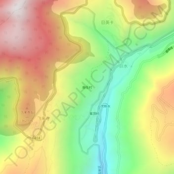
Name: Nanren topographic map, elevation, terrain.
Location: Nanren, Shengping, Dêqên County, Diqing, Yunnan, China (28.43339 98.87168 28.47339 98.91168)
Average elevation: 3,300 m
Minimum elevation: 2,617 m
Maximum elevation: 4,035 m
Thank you for supporting this site ❤️
Make a donation
Make a donation
Gear up for your next adventure:
As an Amazon Associate, this site earns from qualifying purchases at no extra cost to you.