
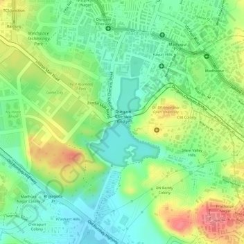
Durgam Cheruvu topographic map
Interactive map
Click on the map to display elevation.
About this map
Name: Durgam Cheruvu topographic map, elevation, terrain.
Average elevation: 577 m
Minimum elevation: 540 m
Maximum elevation: 629 m
Other topographic maps
Click on a map to view its topography, its elevation and its terrain.
Ward 104 Kondapur
Ward 104 Kondapur, Greater Hyderabad Municipal Corporation West Zone, Hyderabad, Rangareddy, Telangana, India
Average elevation: 582 m
Amber cheruvu
Amber cheruvu, Eswar Villas road, Sreenivasa Nagar, Ward 123 Hydernagar, Greater Hyderabad Municipal Corporation West Zone, Hyderabad, Kukatpally mandal, Medchal–Malkajgiri, Telangana, 500085, India
Average elevation: 590 m
Greater Hyderabad Municipal Corporation Central Zone
Greater Hyderabad Municipal Corporation Central Zone, Hyderabad, Khairatabad mandal, Hyderabad, Telangana, India
Average elevation: 533 m
Greater Hyderabad Municipal Corporation South Zone
Greater Hyderabad Municipal Corporation South Zone, Hyderabad, Bahadurpura mandal, Hyderabad, Telangana, India
Average elevation: 535 m
Kappala Cheruvu
Kappala Cheruvu, SH19, sripuram, Ward 14 BN Reddy Nagar, Greater Hyderabad Municipal Corporation East Zone, Hyderabad, Hayathnagar mandal, Rangareddy, Telangana, 500070, India
Average elevation: 537 m
Ward 135 Venkatapuram
Ward 135 Venkatapuram, Greater Hyderabad Municipal Corporation North Zone, Hyderabad, Medchal–Malkajgiri, Telangana, India
Average elevation: 556 m
JawaharNagar Colony Park
JawaharNagar Colony Park, Jawahar Nagar Colony, Ward 148 Ramgopalpet, Greater Hyderabad Municipal Corporation North Zone, Hyderabad, Secunderabad mandal, Hyderabad, Telangana, India
Average elevation: 524 m