
Make a donation
Gear up for your next adventure:
As an Amazon Associate, this site earns from qualifying purchases at no extra cost to you.
Gordonville topographic map
Click on the map to display elevation.
Make a donation
Gear up for your next adventure:
As an Amazon Associate, this site earns from qualifying purchases at no extra cost to you.
About this map
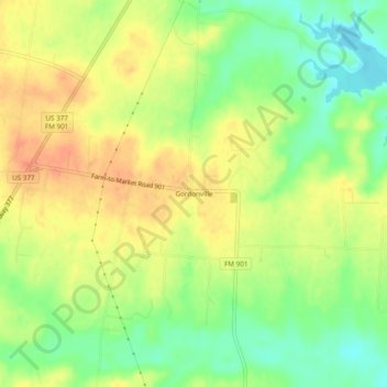
Name: Gordonville topographic map, elevation, terrain.
Location: Gordonville, Grayson County, Texas, United States (33.77566 -96.87306 33.81566 -96.83306)
Average elevation: 211 m
Minimum elevation: 186 m
Maximum elevation: 231 m
Make a donation
Gear up for your next adventure:
As an Amazon Associate, this site earns from qualifying purchases at no extra cost to you.
Other topographic maps
Click on a map to view its topography, its elevation and its terrain.
Make a donation
Gear up for your next adventure:
As an Amazon Associate, this site earns from qualifying purchases at no extra cost to you.
Howe
United States > Texas > Grayson County
Howe's elevation of 860 feet (260 m) is the highest point along US 75 between the Red River and the Gulf of Mexico.
Average elevation: 248 m
Make a donation
Gear up for your next adventure:
As an Amazon Associate, this site earns from qualifying purchases at no extra cost to you.
Make a donation
Gear up for your next adventure:
As an Amazon Associate, this site earns from qualifying purchases at no extra cost to you.