
Make a donation
Gear up for your next adventure:
As an Amazon Associate, this site earns from qualifying purchases at no extra cost to you.
Brannenburg topographic map
Click on the map to display elevation.
Make a donation
Gear up for your next adventure:
As an Amazon Associate, this site earns from qualifying purchases at no extra cost to you.
About this map
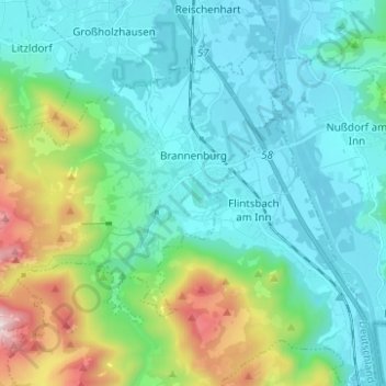
Name: Brannenburg topographic map, elevation, terrain.
Location: Brannenburg, Landkreis Rosenheim, Beieren, 83098, Duitsland (47.69854 12.00871 47.76007 12.13273)
Average elevation: 678 m
Minimum elevation: 447 m
Maximum elevation: 1,568 m
Make a donation
Gear up for your next adventure:
As an Amazon Associate, this site earns from qualifying purchases at no extra cost to you.
Other topographic maps
Click on a map to view its topography, its elevation and its terrain.
Make a donation
Gear up for your next adventure:
As an Amazon Associate, this site earns from qualifying purchases at no extra cost to you.
Wolfsschlucht (Unterer Wasserfall)
Duitsland > Beieren > Landkreis Rosenheim > Flintsbach am Inn
Average elevation: 612 m
Make a donation
Gear up for your next adventure:
As an Amazon Associate, this site earns from qualifying purchases at no extra cost to you.