
Saint-Vite topographic map
Interactive map
Click on the map to display elevation.
About this map
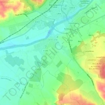
Name: Saint-Vite topographic map, elevation, terrain.
Average elevation: 85 m
Minimum elevation: 55 m
Maximum elevation: 143 m
La superficie de la commune est de 547 hectares ; son altitude varie de 57 à 105 mètres.
Other topographic maps
Click on a map to view its topography, its elevation and its terrain.
Saint-Eutrope-de-Born
France > Nouvelle-Aquitaine > Lot-et-Garonne
Saint-Eutrope-de-Born, Villeneuve-sur-Lot, Lot-et-Garonne, Nouvelle-Aquitaine, France métropolitaine, 47210, France
Average elevation: 127 m
Agen
France > Nouvelle-Aquitaine > Lot-et-Garonne
Agen, Lot-et-Garonne, Nouvelle-Aquitaine, France métropolitaine, 47000, France
Average elevation: 65 m
Monsempron-Libos
France > Nouvelle-Aquitaine > Lot-et-Garonne
Monsempron-Libos, Villeneuve-sur-Lot, Lot-et-Garonne, Nouvelle-Aquitaine, France métropolitaine, 47500, France
Average elevation: 106 m
Prayssas
France > Nouvelle-Aquitaine > Lot-et-Garonne
Prayssas, Agen, Lot-et-Garonne, Nouvelle-Aquitaine, France métropolitaine, 47360, France
Average elevation: 136 m
Meneaux
France > Nouvelle-Aquitaine > Lot-et-Garonne
Meneaux, Feugarolles, Nérac, Lot-et-Garonne, Nouvelle-Aquitaine, France métropolitaine, 47230, France
Average elevation: 43 m
Moncrabeau
France > Nouvelle-Aquitaine > Lot-et-Garonne
Moncrabeau, Nérac, Lot-et-Garonne, Nouvelle-Aquitaine, France métropolitaine, 47600, France
Average elevation: 107 m
Saint-Pierre-de-Clairac
France > Nouvelle-Aquitaine > Lot-et-Garonne
Saint-Pierre-de-Clairac, Agen, Lot-et-Garonne, Nouvelle-Aquitaine, France métropolitaine, 47270, France
Average elevation: 102 m
Sainte-Bazeille
France > Nouvelle-Aquitaine > Lot-et-Garonne
Sainte-Bazeille, Marmande, Lot-et-Garonne, Nouvelle-Aquitaine, France métropolitaine, 47180, France
Average elevation: 28 m
Marmande
France > Nouvelle-Aquitaine > Lot-et-Garonne
Marmande, Lot-et-Garonne, Nouvelle-Aquitaine, France métropolitaine, 47200, France
Average elevation: 41 m
Cocumont
France > Nouvelle-Aquitaine > Lot-et-Garonne
Cocumont, Marmande, Lot-et-Garonne, Nouvelle-Aquitaine, France métropolitaine, 47250, France
Average elevation: 94 m
Barbaste
France > Nouvelle-Aquitaine > Lot-et-Garonne
Barbaste, Nérac, Lot-et-Garonne, Nouvelle-Aquitaine, France métropolitaine, 47230, France
Average elevation: 99 m
Saint-Étienne-de-Fougères
France > Nouvelle-Aquitaine > Lot-et-Garonne
Saint-Étienne-de-Fougères, Villeneuve-sur-Lot, Lot-et-Garonne, Nouvelle-Aquitaine, France métropolitaine, 47380, France
Average elevation: 54 m
Lacapelle-Biron
France > Nouvelle-Aquitaine > Lot-et-Garonne
Lacapelle-Biron, Villeneuve-sur-Lot, Lot-et-Garonne, Nouvelle-Aquitaine, France métropolitaine, 47150, France
Average elevation: 199 m
Lusignan-Petit
France > Nouvelle-Aquitaine > Lot-et-Garonne
Lusignan-Petit, Agen, Lot-et-Garonne, Nouvelle-Aquitaine, France métropolitaine, 47360, France
Average elevation: 118 m
Lustrac
France > Nouvelle-Aquitaine > Lot-et-Garonne > Trentels
Lustrac, Trentels, Villeneuve-sur-Lot, Lot-et-Garonne, Nouvelle-Aquitaine, France métropolitaine, 47140, France
Average elevation: 91 m
Saint-Étienne-de-Villeréal
France > Nouvelle-Aquitaine > Lot-et-Garonne
Saint-Étienne-de-Villeréal, Villeneuve-sur-Lot, Lot-et-Garonne, Nouvelle-Aquitaine, France métropolitaine, 47210, France
Average elevation: 135 m
Trentels
France > Nouvelle-Aquitaine > Lot-et-Garonne
Trentels, Villeneuve-sur-Lot, Lot-et-Garonne, Nouvelle-Aquitaine, France métropolitaine, 47140, France
Average elevation: 107 m
Meylan
France > Nouvelle-Aquitaine > Lot-et-Garonne > Sos
Meylan, Sos, Nérac, Lot-et-Garonne, Nouvelle-Aquitaine, France métropolitaine, 47170, France
Average elevation: 128 m
47400
France > Nouvelle-Aquitaine > Lot-et-Garonne > Varès
47400, Varès, Marmande, Lot-et-Garonne, Nouvelle-Aquitaine, France métropolitaine, France
Average elevation: 58 m
47300
France > Nouvelle-Aquitaine > Lot-et-Garonne > Villeneuve-sur-Lot
47300, Saint-Cyr, Villeneuve-sur-Lot, Lot-et-Garonne, Nouvelle-Aquitaine, France métropolitaine, France
Average elevation: 65 m
Monsalès
France > Nouvelle-Aquitaine > Lot-et-Garonne > Tonneins
Monsalès, Tonneins, Marmande, Lot-et-Garonne, Nouvelle-Aquitaine, France métropolitaine, 47400, France
Average elevation: 32 m
Bouglon
France > Nouvelle-Aquitaine > Lot-et-Garonne
Bouglon, Marmande, Lot-et-Garonne, Nouvelle-Aquitaine, France métropolitaine, 47250, France
Average elevation: 84 m
Beauziac
France > Nouvelle-Aquitaine > Lot-et-Garonne
Beauziac, Nérac, Lot-et-Garonne, Nouvelle-Aquitaine, France métropolitaine, 47700, France
Average elevation: 104 m
47170
France > Nouvelle-Aquitaine > Lot-et-Garonne > Poudenas
47170, Barroc, Poudenas, Nérac, Lot-et-Garonne, Nouvelle-Aquitaine, France métropolitaine, France
Average elevation: 117 m
Gontaud-de-Nogaret
France > Nouvelle-Aquitaine > Lot-et-Garonne
Gontaud-de-Nogaret, Marmande, Lot-et-Garonne, Nouvelle-Aquitaine, France métropolitaine, 47400, France
Average elevation: 62 m
47380
France > Nouvelle-Aquitaine > Lot-et-Garonne > Montastruc
47380, Montastruc, Villeneuve-sur-Lot, Lot-et-Garonne, Nouvelle-Aquitaine, France métropolitaine, France
Average elevation: 104 m
Saint-Sardos
France > Nouvelle-Aquitaine > Lot-et-Garonne
Saint-Sardos, Agen, Lot-et-Garonne, Nouvelle-Aquitaine, France métropolitaine, 47360, France
Average elevation: 87 m
Saint-Front-sur-Lémance
France > Nouvelle-Aquitaine > Lot-et-Garonne
Saint-Front-sur-Lémance, Villeneuve-sur-Lot, Lot-et-Garonne, Nouvelle-Aquitaine, France métropolitaine, 47500, France
Average elevation: 171 m
Escassefort
France > Nouvelle-Aquitaine > Lot-et-Garonne
Escassefort, Marmande, Lot-et-Garonne, Nouvelle-Aquitaine, France métropolitaine, 47350, France
Average elevation: 89 m
Troupenat
France > Nouvelle-Aquitaine > Lot-et-Garonne > Penne-d'Agenais
Troupenat, Penne-d'Agenais, Villeneuve-sur-Lot, Lot-et-Garonne, Nouvelle-Aquitaine, France métropolitaine, 47140, France
Average elevation: 130 m
Cazideroque
France > Nouvelle-Aquitaine > Lot-et-Garonne
Cazideroque, Villeneuve-sur-Lot, Lot-et-Garonne, Nouvelle-Aquitaine, France métropolitaine, 47370, France
Average elevation: 131 m
Castelmoron-sur-Lot
France > Nouvelle-Aquitaine > Lot-et-Garonne
Castelmoron-sur-Lot, Marmande, Lot-et-Garonne, Nouvelle-Aquitaine, France métropolitaine, 47260, France
Average elevation: 81 m
Hautefage-la-Tour
France > Nouvelle-Aquitaine > Lot-et-Garonne
Hautefage-la-Tour, Villeneuve-sur-Lot, Lot-et-Garonne, Nouvelle-Aquitaine, France métropolitaine, 47340, France
Average elevation: 149 m
Port-Sainte-Marie
France > Nouvelle-Aquitaine > Lot-et-Garonne
Port-Sainte-Marie, Agen, Lot-et-Garonne, Nouvelle-Aquitaine, France métropolitaine, 47130, France
Average elevation: 110 m
Montpouillan
France > Nouvelle-Aquitaine > Lot-et-Garonne
Montpouillan, Marmande, Lot-et-Garonne, Nouvelle-Aquitaine, France métropolitaine, 47200, France
Average elevation: 52 m
Massels
France > Nouvelle-Aquitaine > Lot-et-Garonne
Massels, Villeneuve-sur-Lot, Lot-et-Garonne, Nouvelle-Aquitaine, France métropolitaine, 47140, France
Average elevation: 173 m
Sauveterre-la-Lémance
France > Nouvelle-Aquitaine > Lot-et-Garonne
Sauveterre-la-Lémance, Villeneuve-sur-Lot, Lot-et-Garonne, Nouvelle-Aquitaine, France métropolitaine, 47500, France
Average elevation: 197 m
Las Brugues
France > Nouvelle-Aquitaine > Lot-et-Garonne > Monsempron-Libos
Las Brugues, Monsempron-Libos, Villeneuve-sur-Lot, Lot-et-Garonne, Nouvelle-Aquitaine, France métropolitaine, 47500, France
Average elevation: 110 m
Saint-Antoine-de-Ficalba
France > Nouvelle-Aquitaine > Lot-et-Garonne
Saint-Antoine-de-Ficalba, Villeneuve-sur-Lot, Lot-et-Garonne, Nouvelle-Aquitaine, France métropolitaine, 47340, France
Average elevation: 179 m
Réaup-Lisse
France > Nouvelle-Aquitaine > Lot-et-Garonne
Réaup-Lisse, Nérac, Lot-et-Garonne, Nouvelle-Aquitaine, France métropolitaine, 47170, France
Average elevation: 119 m
Cuzorn
France > Nouvelle-Aquitaine > Lot-et-Garonne
Cuzorn, Villeneuve-sur-Lot, Lot-et-Garonne, Nouvelle-Aquitaine, France métropolitaine, 47500, France
Average elevation: 158 m
Fieux
France > Nouvelle-Aquitaine > Lot-et-Garonne
Fieux, Nérac, Lot-et-Garonne, Nouvelle-Aquitaine, France métropolitaine, 47600, France
Average elevation: 114 m
Gandaille
France > Nouvelle-Aquitaine > Lot-et-Garonne > Dondas
Gandaille, Dondas, Agen, Lot-et-Garonne, Nouvelle-Aquitaine, France métropolitaine, 47470, France
Average elevation: 168 m
Aiguillon
France > Nouvelle-Aquitaine > Lot-et-Garonne
Aiguillon, Agen, Lot-et-Garonne, Nouvelle-Aquitaine, France métropolitaine, 47190, France
Average elevation: 54 m
Ladignac
France > Nouvelle-Aquitaine > Lot-et-Garonne
Ladignac, Trentels, Villeneuve-sur-Lot, Lot-et-Garonne, Nouvelle-Aquitaine, France métropolitaine, 47140, France
Average elevation: 91 m
Gautouil
France > Nouvelle-Aquitaine > Lot-et-Garonne > Monségur
Gautouil, Monségur, Villeneuve-sur-Lot, Lot-et-Garonne, Nouvelle-Aquitaine, France métropolitaine, 47150, France
Average elevation: 141 m
Feugarolles
France > Nouvelle-Aquitaine > Lot-et-Garonne
Feugarolles, Nérac, Lot-et-Garonne, Nouvelle-Aquitaine, France métropolitaine, 47230, France
Average elevation: 79 m
Laroque-Timbaut
France > Nouvelle-Aquitaine > Lot-et-Garonne
Laroque-Timbaut, Agen, Lot-et-Garonne, Nouvelle-Aquitaine, France métropolitaine, 47340, France
Average elevation: 174 m
Bordeneuve
France > Nouvelle-Aquitaine > Lot-et-Garonne > Pont-du-Casse
Bordeneuve, Pont-du-Casse, Agen, Lot-et-Garonne, Nouvelle-Aquitaine, France métropolitaine, 47480, France
Average elevation: 134 m
Port de Penne
France > Nouvelle-Aquitaine > Lot-et-Garonne
Port de Penne, Penne-d'Agenais, Villeneuve-sur-Lot, Lot-et-Garonne, Nouvelle-Aquitaine, France métropolitaine, 47140, France
Average elevation: 86 m