
Make a donation
Gear up for your next adventure:
As an Amazon Associate, this site earns from qualifying purchases at no extra cost to you.
Santa Catarina topographic map
Click on the map to display elevation.
Make a donation
Gear up for your next adventure:
As an Amazon Associate, this site earns from qualifying purchases at no extra cost to you.
Santa Catarina
It is one of the Brazilian states with the most mountainous terrain, where 52% of the territory is located above 600 metres. According to the Köppen-Geiger climate classification system, Santa Catarina predominantly features a humid subtropical climate (Cfa) in the coastal lowlands and the lower altitude areas of the plateau, whilst the remainder of the plateau is characterised by an oceanic climate (Cfb).
Make a donation
Gear up for your next adventure:
As an Amazon Associate, this site earns from qualifying purchases at no extra cost to you.
About this map
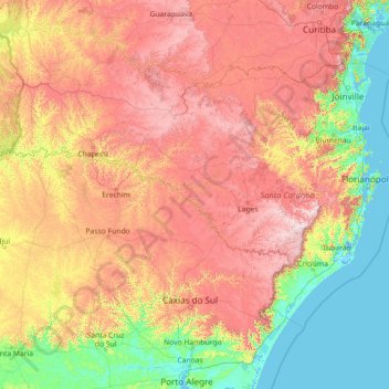
Name: Santa Catarina topographic map, elevation, terrain.
Location: Santa Catarina, South Region, Brazil (-29.44091 -53.83735 -25.95572 -48.10211)
Average elevation: 530 m
Minimum elevation: -3 m
Maximum elevation: 1,778 m
Make a donation
Gear up for your next adventure:
As an Amazon Associate, this site earns from qualifying purchases at no extra cost to you.
Other topographic maps
Click on a map to view its topography, its elevation and its terrain.
Amazon River
During what many archaeologists called the formative stage, Amazonian societies were deeply involved in the emergence of South America's highland agrarian systems. The trade with Andean civilizations in the terrains of the headwaters in the Andes formed an essential contribution to the social and religious…
Average elevation: 5 m
Amazon River
During what many archaeologists called the formative stage, Amazonian societies were deeply involved in the emergence of South America's highland agrarian systems. The trade with Andean civilizations in the terrains of the headwaters in the Andes formed an essential contribution to the social and religious…
Average elevation: 4 m
Make a donation
Gear up for your next adventure:
As an Amazon Associate, this site earns from qualifying purchases at no extra cost to you.
Jardim Copacabana
Brazil > São Paulo > Região Metropolitana de São Paulo > São Paulo
Average elevation: 792 m
Rio de Janeiro
Brazil > Rio de Janeiro > Região Metropolitana do Rio de Janeiro > Rio de Janeiro
Temperature also varies according to elevation, distance from the coast, and type of vegetation or land use. During the winter, cold fronts and dawn/morning sea breezes bring mild temperatures; cold fronts, the Intertropical Convergence Zone (in the form of winds from the Amazon Forest), the strongest…
Average elevation: 40 m
Make a donation
Gear up for your next adventure:
As an Amazon Associate, this site earns from qualifying purchases at no extra cost to you.