
Polokwane topographic map
Interactive map
Click on the map to display elevation.
About this map
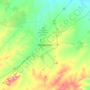
Name: Polokwane topographic map, elevation, terrain.
Average elevation: 1,305 m
Minimum elevation: 1,150 m
Maximum elevation: 1,675 m
Other topographic maps
Click on a map to view its topography, its elevation and its terrain.
Soekmekaar (Morebeng)
South Africa > Limpopo > Capricorn District Municipality > Molemole Local Municipality
Soekmekaar (Morebeng), Molemole Local Municipality, Capricorn District Municipality, Limpopo, South Africa
Average elevation: 1,158 m