
Make a donation
Gear up for your next adventure:
As an Amazon Associate, this site earns from qualifying purchases at no extra cost to you.
Cecil Township topographic map
Click on the map to display elevation.
Make a donation
Gear up for your next adventure:
As an Amazon Associate, this site earns from qualifying purchases at no extra cost to you.
About this map
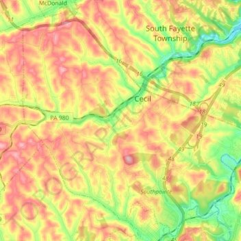
Name: Cecil Township topographic map, elevation, terrain.
Average elevation: 342 m
Minimum elevation: 251 m
Maximum elevation: 427 m
Make a donation
Gear up for your next adventure:
As an Amazon Associate, this site earns from qualifying purchases at no extra cost to you.
Other topographic maps
Click on a map to view its topography, its elevation and its terrain.
Cowden
United States > Pennsylvania > Washington County > Cecil Township > Cecil
Average elevation: 346 m
Millsboro
United States > Pennsylvania > Washington County > East Bethlehem Township
Average elevation: 308 m
Make a donation
Gear up for your next adventure:
As an Amazon Associate, this site earns from qualifying purchases at no extra cost to you.
South Strabane
United States > Pennsylvania > Washington County > South Strabane Township
Average elevation: 377 m
Vance
United States > Pennsylvania > Washington County > South Strabane Township
Average elevation: 371 m
Munntown
United States > Pennsylvania > Washington County > Nottingham Township
Average elevation: 351 m
Make a donation
Gear up for your next adventure:
As an Amazon Associate, this site earns from qualifying purchases at no extra cost to you.
Lover
United States > Pennsylvania > Washington County > Fallowfield Township
Average elevation: 358 m
Enterprise
United States > Pennsylvania > Washington County > South Strabane Township
Average elevation: 334 m
Linden
United States > Pennsylvania > Washington County > North Strabane Township
Average elevation: 331 m
Make a donation
Gear up for your next adventure:
As an Amazon Associate, this site earns from qualifying purchases at no extra cost to you.
Victory Hills
United States > Pennsylvania > Washington County > Carroll Township
Average elevation: 306 m
Chambers Mill
United States > Pennsylvania > Washington County > South Franklin Township
Average elevation: 366 m
Blainsburg
United States > Pennsylvania > Washington County > West Brownsville
Average elevation: 298 m
Mount Wheeler
United States > Pennsylvania > Washington County > North Franklin Township
Average elevation: 382 m
Make a donation
Gear up for your next adventure:
As an Amazon Associate, this site earns from qualifying purchases at no extra cost to you.
Strabane
United States > Pennsylvania > Washington County > North Strabane Township > Strabane
Average elevation: 329 m
Make a donation
Gear up for your next adventure:
As an Amazon Associate, this site earns from qualifying purchases at no extra cost to you.
Shire Oaks
United States > Pennsylvania > Washington County > Union Township > Shire Oaks
Average elevation: 295 m