
Yanqing District topographic map
Interactive map
Click on the map to display elevation.
About this map
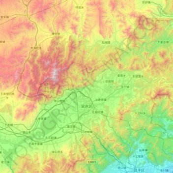
Name: Yanqing District topographic map, elevation, terrain.
Location: Yanqing District, Beijing, 102100, China (40.26430 115.72974 40.78988 116.56832)
Average elevation: 806 m
Minimum elevation: 45 m
Maximum elevation: 2,199 m
The Yanqing Badaling Great Wall Basin is surrounded by mountains on three sides in the north, south, east, and Guanting Reservoir to the west, namely the Yanhuai Basin. Yanqing is located in the east of the basin, with an average elevation of about 500 meters. Haituo Mountain is the highest peak in the territory, with an elevation of 2241 meters and the second highest peak in Beijing.
Other topographic maps
Click on a map to view its topography, its elevation and its terrain.
Mutianyu Great Wall
China > Beijing > Huairou District > Lianhuachi
Mutianyu Great Wall, Great Wall of China, Lianhuachi, Huairou District, Beijing, 101405, China
Average elevation: 430 m
Haidian District
China > Beijing > Haidian District
Haidian District, Beijing, China
Average elevation: 70 m
Capital Airport
China > Beijing > Chaoyang District > Capital Airport
Capital Airport, Chaoyang District, Beijing, 100621, China
Average elevation: 30 m
The Eighth Tower of the North Side
China > Beijing > Yanqing District
The Eighth Tower of the North Side, 长城, Yanqing District, Beijing, China
Average elevation: 752 m
Forbidden City
Forbidden City, Beijing, Dongcheng District, Beijing, 100010, China
Average elevation: 50 m
正白旗村
China > Beijing > Haidian District > 正白旗村
正白旗村, Haidian District, Beijing, 100193, China
Average elevation: 48 m
Qinghe
China > Beijing > Haidian District > Qinghe
Qinghe, Haidian District, Beijing, 100085, China
Average elevation: 47 m
Dongcheng District
China > Beijing > Dongcheng District
Beijing, Dongcheng District, Beijing, 100010, China
Average elevation: 497 m
Chaoyang District
China > Beijing > Chaoyang District
Chaoyang District, Beijing, China
Average elevation: 41 m