
Make a donation
Gear up for your next adventure:
As an Amazon Associate, this site earns from qualifying purchases at no extra cost to you.
Mount Merapi National Park topographic map
Click on the map to display elevation.
Make a donation
Gear up for your next adventure:
As an Amazon Associate, this site earns from qualifying purchases at no extra cost to you.
About this map
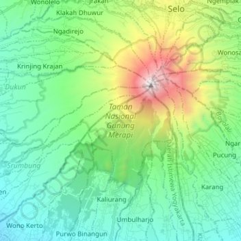
Name: Mount Merapi National Park topographic map, elevation, terrain.
Average elevation: 1,150 m
Minimum elevation: 544 m
Maximum elevation: 2,920 m
Make a donation
Gear up for your next adventure:
As an Amazon Associate, this site earns from qualifying purchases at no extra cost to you.
Other topographic maps
Click on a map to view its topography, its elevation and its terrain.
Gunung Merapi
Indonesia > Special Region of Yogyakarta > Sleman Regency > Hargobinangun
Average elevation: 2,259 m
Ngipiksari
Indonesia > Special Region of Yogyakarta > Sleman Regency > Hargobinangun
Average elevation: 794 m
Sawungan
Indonesia > Special Region of Yogyakarta > Sleman Regency > Hargobinangun
Average elevation: 552 m