Geolocate

Blue Lagoon topographic map

Click on the map to display elevation.

Gear up for your next adventure:

As an Amazon Associate, this site earns from qualifying purchases at no extra cost to you.

About this map

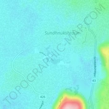
Name: Blue Lagoon topographic map, elevation, terrain.

Location: Blue Lagoon, Grindavíkurbær, Southern Peninsula, Iceland (63.87812 -22.45158 63.88331 -22.43874)

Average elevation: 37 m

Minimum elevation: 17 m

Maximum elevation: 203 m

👉 Easily get elevation data in JSON, GeoTIFF and KML formats using Elevation API
Thank you for supporting this site ❤️
Make a donation

Gear up for your next adventure:

As an Amazon Associate, this site earns from qualifying purchases at no extra cost to you.

Gear up for your next adventure:

🎒Hiking Backpacks - Durable backpacks for day hikes and multi‑day treks
📍Trail Markers & GPS - Tools to track and mark trails
🧤Thermal Outdoor Gloves - Windproof and waterproof gloves for winter hiking

As an Amazon Associate, this site earns from qualifying purchases at no extra cost to you.