
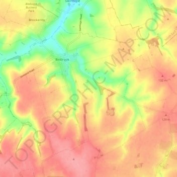
Binbrook topographic map
Interactive map
Click on the map to display elevation.
About this map
Name: Binbrook topographic map, elevation, terrain.
Average elevation: 106 m
Minimum elevation: 52 m
Maximum elevation: 142 m
Other topographic maps
Click on a map to view its topography, its elevation and its terrain.
Spilsby
United Kingdom > England > Lincolnshire > East Lindsey
Spilsby, East Lindsey, Lincolnshire, England, United Kingdom
Average elevation: 32 m
Wragby
United Kingdom > England > Lincolnshire > East Lindsey
Wragby, East Lindsey, Lincolnshire, England, United Kingdom
Average elevation: 25 m
North Elkington
United Kingdom > England > Lincolnshire > East Lindsey
North Elkington, Elkington, East Lindsey, Lincolnshire, England, LN11 0SE, United Kingdom
Average elevation: 102 m
North Cotes
United Kingdom > England > Lincolnshire > East Lindsey
North Cotes, East Lindsey, Lincolnshire, England, DN36 5UT, United Kingdom
Average elevation: 2 m
Hatton
United Kingdom > England > Lincolnshire > East Lindsey
Hatton, East Lindsey, Lincolnshire, England, United Kingdom
Average elevation: 33 m