
Thank you for supporting this site ❤️
Make a donation
Make a donation
Gear up for your next adventure:
As an Amazon Associate, this site earns from qualifying purchases at no extra cost to you.
Fanna topographic map
Click on the map to display elevation.
Thank you for supporting this site ❤️
Make a donation
Make a donation
Gear up for your next adventure:
As an Amazon Associate, this site earns from qualifying purchases at no extra cost to you.
About this map
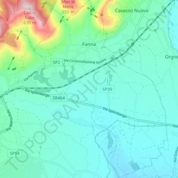
Name: Fanna topographic map, elevation, terrain.
Location: Fanna, Pordenone, Friuli-Venezia Giulia, Italy (46.14975 12.73079 46.19938 12.78476)
Average elevation: 270 m
Minimum elevation: 205 m
Maximum elevation: 603 m
Thank you for supporting this site ❤️
Make a donation
Make a donation
Gear up for your next adventure:
As an Amazon Associate, this site earns from qualifying purchases at no extra cost to you.
Other topographic maps
Click on a map to view its topography, its elevation and its terrain.
Borgo Mieli
Italy > Friuli-Venezia Giulia > Pordenone > Fanna > Fanna > Borgo Mieli
Average elevation: 366 m