Geolocate

Tonna topographic map

Click on the map to display elevation.

About this map
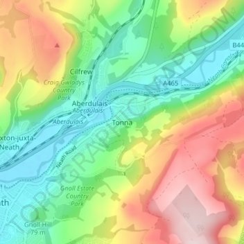
Name: Tonna topographic map, elevation, terrain.

Location: Tonna, Neath Port Talbot, Wales, SA11 3JA, United Kingdom (51.65598 -3.79084 51.69598 -3.75084)

Average elevation: 122 m

Minimum elevation: 2 m

Maximum elevation: 307 m

Other topographic maps

Click on a map to view its topography, its elevation and its terrain.

River Neath

United Kingdom > Wales > Neath Port Talbot > Resolven

Average elevation: 272 m

Glynneath

United Kingdom > Wales > Neath Port Talbot

Average elevation: 246 m

Cilybebyll

United Kingdom > Wales > Neath Port Talbot > Gellinudd

Average elevation: 179 m

Pelenna

United Kingdom > Wales > Neath Port Talbot

Average elevation: 217 m

Crynant

United Kingdom > Wales > Neath Port Talbot

Average elevation: 232 m

Neath

United Kingdom > Wales > Neath Port Talbot

Average elevation: 71 m

Pontardawe

United Kingdom > Wales > Neath Port Talbot

Average elevation: 180 m

Port Talbot

United Kingdom > Wales > Neath Port Talbot

Average elevation: 64 m

Neath

United Kingdom > Wales > Neath Port Talbot

Average elevation: 71 m

Gear up for your next adventure:

📻Emergency Crank Radios - Stay informed in remote areas without power
🧯Compact Fire Extinguishers - Safety for campervans and expedition vehicles
🧂Electrolyte Tablets - Stay hydrated during strenuous mountain climbs
🧢Hiking Hats & Caps - Protective headwear for sun and rain
🏕️Camping Chairs - Comfortable outdoor chairs for campsites

As an Amazon Associate, this site earns from qualifying purchases at no extra cost to you.