
Make a donation
Gear up for your next adventure:
As an Amazon Associate, this site earns from qualifying purchases at no extra cost to you.
Thames River topographic map
Click on the map to display elevation.
Make a donation
Gear up for your next adventure:
As an Amazon Associate, this site earns from qualifying purchases at no extra cost to you.
About this map
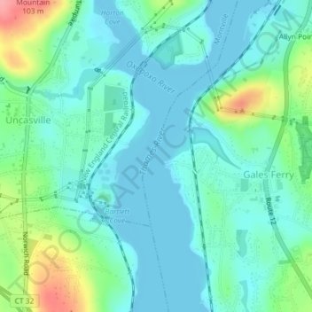
Name: Thames River topographic map, elevation, terrain.
Average elevation: 52 m
Minimum elevation: -3 m
Maximum elevation: 189 m
Make a donation
Gear up for your next adventure:
As an Amazon Associate, this site earns from qualifying purchases at no extra cost to you.
Other topographic maps
Click on a map to view its topography, its elevation and its terrain.
High Rock
United States > Connecticut > Southeastern Connecticut Planning Region > Waterford
Average elevation: 39 m
Manitock Spring
United States > Connecticut > Southeastern Connecticut Planning Region > Waterford
Average elevation: 26 m
Jordan Village
United States > Connecticut > Southeastern Connecticut Planning Region > Waterford
Average elevation: 27 m
Pepperbox Hill
United States > Connecticut > Southeastern Connecticut Planning Region > Waterford
Average elevation: 18 m
Make a donation
Gear up for your next adventure:
As an Amazon Associate, this site earns from qualifying purchases at no extra cost to you.
Quaker Hill
United States > Connecticut > Southeastern Connecticut Planning Region > Waterford
Average elevation: 35 m