
Thank you for supporting this site ❤️
Make a donation
Make a donation
Gear up for your next adventure:
As an Amazon Associate, this site earns from qualifying purchases at no extra cost to you.
Sualkuchi topographic map
Click on the map to display elevation.
Thank you for supporting this site ❤️
Make a donation
Make a donation
Gear up for your next adventure:
As an Amazon Associate, this site earns from qualifying purchases at no extra cost to you.
Sualkuchi
Sualkuchi is located at 26°10′N 91°34′E / 26.17°N 91.57°E / 26.17; 91.57. It has an average elevation of 35 m (115 ft).
Thank you for supporting this site ❤️
Make a donation
Make a donation
Gear up for your next adventure:
As an Amazon Associate, this site earns from qualifying purchases at no extra cost to you.
About this map
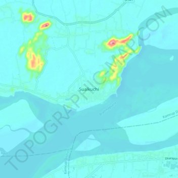
Name: Sualkuchi topographic map, elevation, terrain.
Location: Sualkuchi, Hajo, Kamrup, Assam, 781103, India (26.12991 91.53085 26.20991 91.61085)
Average elevation: 50 m
Minimum elevation: 40 m
Maximum elevation: 164 m
Thank you for supporting this site ❤️
Make a donation
Make a donation
Gear up for your next adventure:
As an Amazon Associate, this site earns from qualifying purchases at no extra cost to you.