
Aach topographic map
Interactive map
Click on the map to display elevation.
About this map
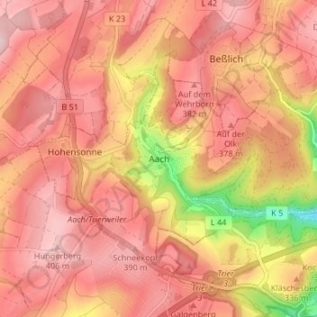
Name: Aach topographic map, elevation, terrain.
Average elevation: 340 m
Minimum elevation: 171 m
Maximum elevation: 416 m
Other topographic maps
Click on a map to view its topography, its elevation and its terrain.
Klüsserath
Deutschland > Rheinland-Pfalz > Landkreis Trier-Saarburg
Klüsserath, Schweich an der Römischen Weinstraße, Landkreis Trier-Saarburg, Rheinland-Pfalz, Deutschland
Average elevation: 227 m
Schöndorf
Deutschland > Rheinland-Pfalz > Landkreis Trier-Saarburg
Schöndorf, Ruwer, Landkreis Trier-Saarburg, Rheinland-Pfalz, Deutschland
Average elevation: 390 m
Kell am See
Deutschland > Rheinland-Pfalz > Landkreis Trier-Saarburg
Kell am See, Saarburg-Kell, Landkreis Trier-Saarburg, Rheinland-Pfalz, 54427, Deutschland
Average elevation: 521 m
Kanzem
Deutschland > Rheinland-Pfalz > Landkreis Trier-Saarburg
Kanzem, Konz, Landkreis Trier-Saarburg, Rheinland-Pfalz, Deutschland
Average elevation: 177 m
Oberzerf
Deutschland > Rheinland-Pfalz > Landkreis Trier-Saarburg
Oberzerf, Zerf, Saarburg-Kell, Landkreis Trier-Saarburg, Rheinland-Pfalz, 54314, Deutschland
Average elevation: 439 m
Mandern
Deutschland > Rheinland-Pfalz > Landkreis Trier-Saarburg
Mandern, Saarburg-Kell, Landkreis Trier-Saarburg, Rheinland-Pfalz, 54429, Deutschland
Average elevation: 525 m
Baldringen
Deutschland > Rheinland-Pfalz > Landkreis Trier-Saarburg
Baldringen, Saarburg-Kell, Landkreis Trier-Saarburg, Rheinland-Pfalz, Deutschland
Average elevation: 425 m
Wellen
Deutschland > Rheinland-Pfalz > Landkreis Trier-Saarburg > Wellen
Wellen, Konz, Landkreis Trier-Saarburg, Rheinland-Pfalz, Deutschland
Average elevation: 208 m
Beuren (Hochwald)
Deutschland > Rheinland-Pfalz > Landkreis Trier-Saarburg > Beuren (Hochwald)
Beuren (Hochwald), Hermeskeil, Landkreis Trier-Saarburg, Rheinland-Pfalz, Deutschland
Average elevation: 479 m