
Cahokia topographic map
Interactive map
Click on the map to display elevation.
About this map
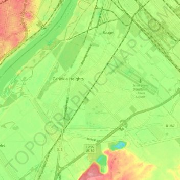
Name: Cahokia topographic map, elevation, terrain.
Location: Cahokia, Saint Clair County, Illinois, 62206, United States (38.54099 -90.22273 38.59017 -90.12467)
Average elevation: 128 m
Minimum elevation: 85 m
Maximum elevation: 180 m
Other topographic maps
Click on a map to view its topography, its elevation and its terrain.
Mascoutah
United States > Illinois > Saint Clair County
Mascoutah, Saint Clair County, Illinois, 62258, United States
Average elevation: 135 m
Smithton
United States > Illinois > Saint Clair County
Smithton, Saint Clair County, Illinois, United States
Average elevation: 147 m
Cahokia Mounds State Historic Site
United States > Illinois > Saint Clair County > Fairmont City
Cahokia Mounds State Historic Site, Fairmont City, Saint Clair County, Illinois, United States
Average elevation: 128 m
Freeburg
United States > Illinois > Saint Clair County
Freeburg, Saint Clair County, Illinois, 62243, United States
Average elevation: 152 m
East Saint Louis
United States > Illinois > Saint Clair County
East Saint Louis, Saint Clair County, Illinois, United States
Average elevation: 130 m
East Carondelet
United States > Illinois > Saint Clair County > East Carondelet
East Carondelet, Saint Clair County, Illinois, United States
Average elevation: 123 m
Shiloh
United States > Illinois > Saint Clair County > Shiloh > Shiloh
Shiloh, Saint Clair County, Illinois, 62269, United States
Average elevation: 158 m
Belleville
United States > Illinois > Saint Clair County > Belleville
Belleville, Saint Clair County, Illinois, 6220, United States
Average elevation: 162 m
Briar Hill
United States > Illinois > Saint Clair County > Briar Hill
Briar Hill, Saint Clair County, Illinois, 62223, United States
Average elevation: 160 m
Washington Park
United States > Illinois > Saint Clair County > Washington Park
Washington Park, Saint Clair County, Illinois, United States
Average elevation: 128 m
O'Fallon
United States > Illinois > Saint Clair County > O'Fallon > O'Fallon
O'Fallon, Saint Clair County, Illinois, 62269, United States
Average elevation: 165 m
Summerfield
United States > Illinois > Saint Clair County
Summerfield, Saint Clair County, Illinois, United States
Average elevation: 149 m
Shiloh
United States > Illinois > Saint Clair County
Shiloh, Saint Clair County, Illinois, United States
Average elevation: 157 m