
Town of Holland topographic map
Interactive map
Click on the map to display elevation.
About this map
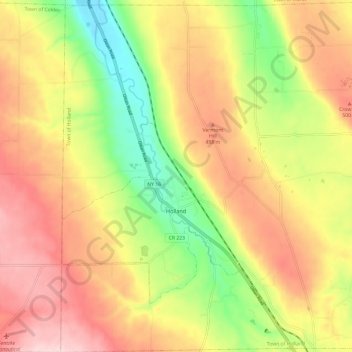
Name: Town of Holland topographic map, elevation, terrain.
Location: Town of Holland, Erie County, New York, 14080, United States (42.60578 -78.58105 42.69392 -78.46174)
Average elevation: 432 m
Minimum elevation: 288 m
Maximum elevation: 561 m
Other topographic maps
Click on a map to view its topography, its elevation and its terrain.
Buffalo
United States > New York > Erie County
Buffalo, Erie County, New York, United States
Average elevation: 185 m
North Boston
United States > New York > Erie County > Town of Boston
North Boston, Town of Boston, Erie County, New York, United States
Average elevation: 305 m
Highland-on-the-Lake
United States > New York > Erie County
Highland-on-the-Lake, Town of Evans, Erie County, New York, 14047, United States
Average elevation: 198 m
Alden Center
United States > New York > Erie County > Town of Alden
Alden Center, Town of Alden, Erie County, New York, 14004, United States
Average elevation: 249 m
Town of Brant
United States > New York > Erie County
Town of Brant, Erie County, New York, United States
Average elevation: 223 m
West Falls
United States > New York > Erie County
West Falls, Town of Aurora, Erie County, New York, 14170, United States
Average elevation: 356 m
North Evans
United States > New York > Erie County
North Evans, Town of Evans, Erie County, New York, 14112, United States
Average elevation: 217 m
Ebenezer
United States > New York > Erie County > Town of West Seneca
Ebenezer, Town of West Seneca, Erie County, New York, 14224, United States
Average elevation: 201 m
Eden
United States > New York > Erie County > Town of Eden
Eden, Town of Eden, Erie County, New York, 14057, United States
Average elevation: 267 m
East Lancaster
United States > New York > Erie County > Town of Lancaster
East Lancaster, Town of Lancaster, Erie County, New York, 14086, United States
Average elevation: 216 m
Collins Center
United States > New York > Erie County > Town of Collins
Collins Center, Town of Collins, Erie County, New York, 14035, United States
Average elevation: 350 m
Village of Angola
United States > New York > Erie County
Village of Angola, Town of Evans, Erie County, New York, United States
Average elevation: 207 m
Murder Creek
United States > New York > Erie County > Village of Akron
Murder Creek, Village of Akron, Town of Newstead, Erie County, New York, United States
Average elevation: 204 m
Village of Farnham
United States > New York > Erie County
Village of Farnham, Town of Brant, Erie County, New York, 14061, United States
Average elevation: 189 m
Dutchtown
United States > New York > Erie County > Town of Holland
Dutchtown, Town of Holland, Erie County, New York, United States
Average elevation: 433 m
South Newstead
United States > New York > Erie County
South Newstead, Town of Newstead, Erie County, New York, United States
Average elevation: 244 m
Williston
United States > New York > Erie County > Town of Marilla
Williston, Town of Marilla, Erie County, New York, 14102, United States
Average elevation: 305 m
Woodlawn
United States > New York > Erie County > Town of Hamburg
Woodlawn, Town of Hamburg, Erie County, New York, 14219, United States
Average elevation: 181 m
East Amherst
United States > New York > Erie County > Town of Clarence
East Amherst, Town of Clarence, Erie County, New York, 14051, United States
Average elevation: 183 m
Town Line
United States > New York > Erie County > Town of Alden
Town Line, Town of Alden, Erie County, New York, United States
Average elevation: 233 m
Loveland
United States > New York > Erie County > Town of Orchard Park
Loveland, Town of Orchard Park, Erie County, New York, 14170, United States
Average elevation: 325 m
Webster Corners
United States > New York > Erie County > Town of Orchard Park
Webster Corners, Town of Orchard Park, Erie County, New York, 14127, United States
Average elevation: 244 m
Windom
United States > New York > Erie County > Town of Orchard Park
Windom, Town of Orchard Park, Erie County, New York, 14219, United States
Average elevation: 217 m
Weyer
United States > New York > Erie County > Town of Hamburg
Weyer, Town of Hamburg, Erie County, New York, 14085, United States
Average elevation: 205 m
North Bailey
United States > New York > Erie County > Town of Amherst
North Bailey, Town of Amherst, Erie County, New York, 14261, United States
Average elevation: 182 m
Bowmansville
United States > New York > Erie County > Town of Lancaster
Bowmansville, Town of Lancaster, Erie County, New York, 14026, United States
Average elevation: 215 m
Langford
United States > New York > Erie County > Town of North Collins
Langford, Town of North Collins, Erie County, New York, United States
Average elevation: 389 m
New Oregon
United States > New York > Erie County > Town of North Collins
New Oregon, Town of North Collins, Erie County, New York, United States
Average elevation: 390 m
Chaffee
United States > New York > Erie County > Town of Sardinia
Chaffee, Town of Sardinia, Erie County, New York, 14030, United States
Average elevation: 456 m
Brighton
United States > New York > Erie County > Town of Tonawanda
Brighton, Town of Tonawanda, Erie County, New York, 14223, United States
Average elevation: 182 m
Wales Center
United States > New York > Erie County
Wales Center, Town of Wales, Erie County, New York, 14169, United States
Average elevation: 317 m
Wales Hollow
United States > New York > Erie County
Wales Hollow, Town of Wales, Erie County, New York, 14169, United States
Average elevation: 347 m
Gardenville
United States > New York > Erie County > Town of West Seneca
Gardenville, Town of West Seneca, Erie County, New York, 14227, United States
Average elevation: 192 m
Griffins Mills
United States > New York > Erie County
Griffins Mills, Town of Aurora, Erie County, New York, 14170, United States
Average elevation: 319 m
Clarksburg
United States > New York > Erie County > Town of Eden
Clarksburg, Town of Eden, Erie County, New York, United States
Average elevation: 350 m
Carnegie
United States > New York > Erie County > Town of Hamburg
Carnegie, Town of Hamburg, Erie County, New York, 14075, United States
Average elevation: 224 m
Wolcottsburg
United States > New York > Erie County > Town of Clarence
Wolcottsburg, Town of Clarence, Erie County, New York, 14032, United States
Average elevation: 180 m
West Alden
United States > New York > Erie County > Town of Alden
West Alden, Town of Alden, Erie County, New York, 14004, United States
Average elevation: 254 m
Pinehurst
United States > New York > Erie County > Town of Hamburg
Pinehurst, Town of Hamburg, Erie County, New York, 14085, United States
Average elevation: 190 m
Locksley Park
United States > New York > Erie County > Town of Hamburg
Locksley Park, Town of Hamburg, Erie County, New York, 14075, United States
Average elevation: 186 m
Water Valley
United States > New York > Erie County > Town of Hamburg
Water Valley, Town of Hamburg, Erie County, New York, 14075, United States
Average elevation: 244 m
Derby
United States > New York > Erie County
Derby, Town of Evans, Erie County, New York, 14047, United States
Average elevation: 213 m
Murrays Corner
United States > New York > Erie County
Murrays Corner, Town of Newstead, Erie County, New York, 14001, United States
Average elevation: 248 m
Porterville
United States > New York > Erie County > Town of Marilla
Porterville, Town of Marilla, Erie County, New York, 14169, United States
Average elevation: 298 m
Dellwood
United States > New York > Erie County > Town of Alden
Dellwood, Town of Alden, Erie County, New York, United States
Average elevation: 233 m
Swifts Mills
United States > New York > Erie County
Swifts Mills, Town of Newstead, Erie County, New York, 14001, United States
Average elevation: 191 m
Sand Hill
United States > New York > Erie County
Sand Hill, Town of Newstead, Erie County, New York, United States
Average elevation: 186 m
Marshfield
United States > New York > Erie County > Town of North Collins
Marshfield, Town of North Collins, Erie County, New York, United States
Average elevation: 398 m
Armor
United States > New York > Erie County > Town of Hamburg
Armor, Town of Hamburg, Erie County, New York, 14075, United States
Average elevation: 246 m
Shirley
United States > New York > Erie County > Town of North Collins
Shirley, Town of North Collins, Erie County, New York, 14111, United States
Average elevation: 322 m