
Make a donation
Gear up for your next adventure:
As an Amazon Associate, this site earns from qualifying purchases at no extra cost to you.
Wustermark topographic map
Click on the map to display elevation.
Make a donation
Gear up for your next adventure:
As an Amazon Associate, this site earns from qualifying purchases at no extra cost to you.
Wustermark
Für den Neubau des Binnenhafens im Ortsteil Wustermark (GVZ) wurde im Juni 2007 der Grundstein gelegt. Die Fertigstellung erfolgte im Jahre 2008, sie hatte rund 15 Millionen Euro gekostet. Den Hauptanteil in Höhe von 12,4 Millionen finanzierte das Land Brandenburg.
Make a donation
Gear up for your next adventure:
As an Amazon Associate, this site earns from qualifying purchases at no extra cost to you.
About this map
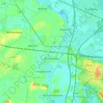
Name: Wustermark topographic map, elevation, terrain.
Location: Wustermark, Havelland, Brandenburg, Deutschland (52.52474 12.87119 52.57819 13.01521)
Average elevation: 37 m
Minimum elevation: 28 m
Maximum elevation: 64 m
Make a donation
Gear up for your next adventure:
As an Amazon Associate, this site earns from qualifying purchases at no extra cost to you.
Other topographic maps
Click on a map to view its topography, its elevation and its terrain.
Make a donation
Gear up for your next adventure:
As an Amazon Associate, this site earns from qualifying purchases at no extra cost to you.
Make a donation
Gear up for your next adventure:
As an Amazon Associate, this site earns from qualifying purchases at no extra cost to you.