
Okehampton topographic map
Interactive map
Click on the map to display elevation.
About this map
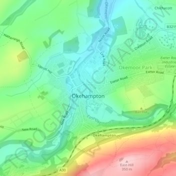
Name: Okehampton topographic map, elevation, terrain.
Location: Okehampton, West Devon, Devon, Angleterre, Royaume-Uni (50.72846 -4.01589 50.74924 -3.98402)
Average elevation: 206 m
Minimum elevation: 135 m
Maximum elevation: 346 m
Other topographic maps
Click on a map to view its topography, its elevation and its terrain.
Vale Down
Royaume-Uni > Angleterre > Devon > West Devon > Lydford > Vale Down
Vale Down, Lydford, West Devon, Devon, South West England, Angleterre, EX20 4BB, Royaume-Uni
Average elevation: 278 m
Princetown
Royaume-Uni > Angleterre > Devon > West Devon
Princetown, Dartmoor Forest, West Devon, Devon, Angleterre, Royaume-Uni
Average elevation: 415 m