
Thank you for supporting this site ❤️
Make a donation
Make a donation
Gear up for your next adventure:
As an Amazon Associate, this site earns from qualifying purchases at no extra cost to you.
Bürgel topographic map
Click on the map to display elevation.
Thank you for supporting this site ❤️
Make a donation
Make a donation
Gear up for your next adventure:
As an Amazon Associate, this site earns from qualifying purchases at no extra cost to you.
About this map
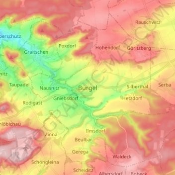
Name: Bürgel topographic map, elevation, terrain.
Location: Bürgel, Saale-Holzland-Kreis, Thuringia, 07616, Germany (50.90893 11.69160 50.97613 11.81671)
Average elevation: 294 m
Minimum elevation: 158 m
Maximum elevation: 390 m
Thank you for supporting this site ❤️
Make a donation
Make a donation
Gear up for your next adventure:
As an Amazon Associate, this site earns from qualifying purchases at no extra cost to you.