
West Papua topographic map
Interactive map
Click on the map to display elevation.
West Papua
West Papua is located between 0–4 degrees South Latitude and 124–132 degrees East Longitude, just below the equator with an altitude of 0–100 m (0–328 ft) above sea level. The area of West Papua is 126,093 km2 (48,685 sq mi).[58]
About this map
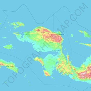
Name: West Papua topographic map, elevation, terrain.
Location: West Papua, Western New Guinea, Indonesia (-4.85172 131.27672 0.56051 135.33417)
Average elevation: 135 m
Minimum elevation: -4 m
Maximum elevation: 3,622 m
Other topographic maps
Click on a map to view its topography, its elevation and its terrain.