
Make a donation
Gear up for your next adventure:
As an Amazon Associate, this site earns from qualifying purchases at no extra cost to you.
Madikeri topographic map
Click on the map to display elevation.
Make a donation
Gear up for your next adventure:
As an Amazon Associate, this site earns from qualifying purchases at no extra cost to you.
Madikeri
Madikeri features a tropical highland climate as it has an elevation of 1,170 m (3,840 ft). Madikeri is located at 12°25′N 75°44′E / 12.42°N 75.73°E / 12.42; 75.73. Madikeri lies in the Western Ghats and is a popular hill station. The nearest cities are Hassan to the north, Mangaluru to the west, and Mysuru to the east. Kannur from Kerala is about 100 km (62 mi) away. The nearest international airport is Kannur International Airport which is 80 km (50 mi) away.
Make a donation
Gear up for your next adventure:
As an Amazon Associate, this site earns from qualifying purchases at no extra cost to you.
About this map
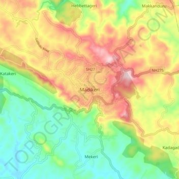
Name: Madikeri topographic map, elevation, terrain.
Location: Madikeri, Madikeri taluku, Kodagu, Karnataka, 571201, India (12.38149 75.69875 12.46149 75.77875)
Average elevation: 1,054 m
Minimum elevation: 880 m
Maximum elevation: 1,283 m
Make a donation
Gear up for your next adventure:
As an Amazon Associate, this site earns from qualifying purchases at no extra cost to you.