
Make a donation
Gear up for your next adventure:
As an Amazon Associate, this site earns from qualifying purchases at no extra cost to you.
Ouarzazate topographic map
Click on the map to display elevation.
Make a donation
Gear up for your next adventure:
As an Amazon Associate, this site earns from qualifying purchases at no extra cost to you.
Ouarzazate
Ouarzazate (/ˌwɑːrzəˈzæt, -ˈzɑːt/; Arabic: ورزازات, romanized: Warzāzāt, IPA: [warzaːˈzaːt]; Moroccan Arabic: وارزازات, romanized: Wārzāzāt; Berber: ⵡⴰⵔⵣⴰⵣⴰⵜ, romanized: Warzazat), nicknamed the door of the desert, is a city and capital of Ouarzazate Province in the region of Drâa-Tafilalet, south-central Morocco. Ouarzazate is at an elevation of 1,160 metres (3,810 ft) in the middle of a bare plateau south of the High Atlas Mountains, with a desert to the city's south.
Make a donation
Gear up for your next adventure:
As an Amazon Associate, this site earns from qualifying purchases at no extra cost to you.
About this map
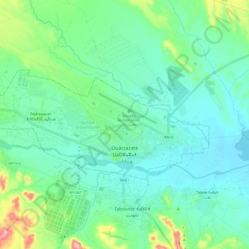
Name: Ouarzazate topographic map, elevation, terrain.
Average elevation: 1,144 m
Minimum elevation: 1,101 m
Maximum elevation: 1,289 m
Make a donation
Gear up for your next adventure:
As an Amazon Associate, this site earns from qualifying purchases at no extra cost to you.