
Snowdon topographic map
Interactive map
Click on the map to display elevation.
About this map
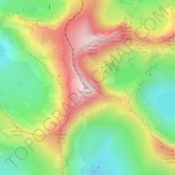
Name: Snowdon topographic map, elevation, terrain.
Location: Snowdon, Gwynedd, Wales, LL55 4UL, United Kingdom (53.06844 -4.07628 53.06854 -4.07618)
Average elevation: 692 m
Minimum elevation: 390 m
Maximum elevation: 1,061 m
Snowdon (/ˈsnoʊdən/) or Yr Wyddfa (pronounced [ər ˈʊɨ̞̯ðva] (listen)) is the highest mountain in Wales, at an elevation of 1,085 metres (3,560 ft) above sea level, and the highest point in the British Isles outside the Scottish Highlands. It is located in Snowdonia National Park (Parc Cenedlaethol Eryri) in Gwynedd (historic county of Caernarfonshire).
Other topographic maps
Click on a map to view its topography, its elevation and its terrain.
Sand Dunes
United Kingdom > Wales > Gwynedd > Barmouth
Sand Dunes, Arthog, Barmouth, Gwynedd, Wales, United Kingdom
Average elevation: 10 m
Porth Dinllaen
United Kingdom > Wales > Gwynedd > Morfa Nefyn
Porth Dinllaen, Nefyn, Morfa Nefyn, Gwynedd, Wales, LL53 6DB, United Kingdom
Average elevation: 8 m