
Make a donation
Gear up for your next adventure:
As an Amazon Associate, this site earns from qualifying purchases at no extra cost to you.
Parque de las iguanas topographic map
Click on the map to display elevation.
Make a donation
Gear up for your next adventure:
As an Amazon Associate, this site earns from qualifying purchases at no extra cost to you.
About this map
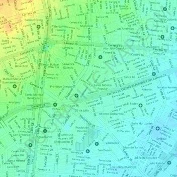
Name: Parque de las iguanas topographic map, elevation, terrain.
Average elevation: 959 m
Minimum elevation: 948 m
Maximum elevation: 978 m
Make a donation
Gear up for your next adventure:
As an Amazon Associate, this site earns from qualifying purchases at no extra cost to you.
Other topographic maps
Click on a map to view its topography, its elevation and its terrain.
San Marino
Colombia > Valle del Cauca > Cali > Perímetro Urbano Santiago de Cali
Average elevation: 952 m
El Refugio
Colombia > Valle del Cauca > Cali > Perímetro Urbano Santiago de Cali
Average elevation: 991 m
Aranjuez
Colombia > Valle del Cauca > Cali > Perímetro Urbano Santiago de Cali
Average elevation: 965 m
Viejo San Fernando
Colombia > Valle del Cauca > Cali > Perímetro Urbano Santiago de Cali
Average elevation: 1,023 m
Make a donation
Gear up for your next adventure:
As an Amazon Associate, this site earns from qualifying purchases at no extra cost to you.
Nápoles
Colombia > Valle del Cauca > Cali > Perímetro Urbano Santiago de Cali
Average elevation: 997 m
Parque del Perro
Colombia > Valle del Cauca > Cali > Perímetro Urbano Santiago de Cali
Average elevation: 1,035 m
Parque La Flora
Colombia > Valle del Cauca > Cali > Perímetro Urbano Santiago de Cali
Average elevation: 997 m
Comuna 13
Colombia > Valle del Cauca > Cali > Perímetro Urbano Santiago de Cali
Average elevation: 950 m
Make a donation
Gear up for your next adventure:
As an Amazon Associate, this site earns from qualifying purchases at no extra cost to you.
El Peñón
Colombia > Valle del Cauca > Cali > Perímetro Urbano Santiago de Cali
Average elevation: 1,050 m
Santa Fé
Colombia > Valle del Cauca > Cali > Perímetro Urbano Santiago de Cali
Average elevation: 957 m
Comuna 2
Colombia > Valle del Cauca > Cali > Perímetro Urbano Santiago de Cali
Average elevation: 1,046 m
Sector Patio Bonito
Colombia > Valle del Cauca > Cali > Perímetro Urbano Santiago de Cali
Average elevation: 1,349 m
Make a donation
Gear up for your next adventure:
As an Amazon Associate, this site earns from qualifying purchases at no extra cost to you.
Parque Barrio Obrero
Colombia > Valle del Cauca > Cali > Perímetro Urbano Santiago de Cali
Average elevation: 973 m
Comuna 7
Colombia > Valle del Cauca > Cali > Perímetro Urbano Santiago de Cali
Average elevation: 954 m
Menga
Colombia > Valle del Cauca > Cali > Perímetro Urbano Santiago de Cali
Average elevation: 1,033 m
Farallones
Colombia > Valle del Cauca > Cali > Perímetro Urbano Santiago de Cali
Average elevation: 1,012 m
Make a donation
Gear up for your next adventure:
As an Amazon Associate, this site earns from qualifying purchases at no extra cost to you.
Bellavista
Colombia > Valle del Cauca > Cali > Perímetro Urbano Santiago de Cali
Average elevation: 1,095 m
Unicentro Cali
Colombia > Valle del Cauca > Cali > Perímetro Urbano Santiago de Cali
Average elevation: 984 m
La Merced
Colombia > Valle del Cauca > Cali > Perímetro Urbano Santiago de Cali
Average elevation: 964 m
Chapinero
Colombia > Valle del Cauca > Cali > Perímetro Urbano Santiago de Cali
Average elevation: 956 m
Make a donation
Gear up for your next adventure:
As an Amazon Associate, this site earns from qualifying purchases at no extra cost to you.
Comuna 10
Colombia > Valle del Cauca > Cali > Perímetro Urbano Santiago de Cali
Average elevation: 960 m
San Cristobal
Colombia > Valle del Cauca > Cali > Perímetro Urbano Santiago de Cali
Average elevation: 961 m
Zona B - Jardín Botánico. Parque Tecnológico, Estación experimental
Colombia > Valle del Cauca > Cali > Perímetro Urbano Santiago de Cali
Average elevation: 972 m
Prados del Sur
Colombia > Valle del Cauca > Cali > Perímetro Urbano Santiago de Cali
Average elevation: 1,031 m
Make a donation
Gear up for your next adventure:
As an Amazon Associate, this site earns from qualifying purchases at no extra cost to you.
La Alianza
Colombia > Valle del Cauca > Cali > Perímetro Urbano Santiago de Cali
Average elevation: 961 m