Geolocate

Hartlepool topographic map

Click on the map to display elevation.

About this map

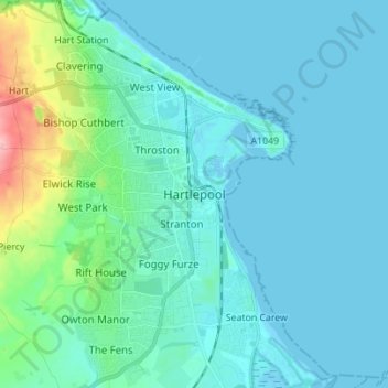
Name: Hartlepool topographic map, elevation, terrain.

Location: Hartlepool, Tees Valley, England, TS24 7EQ, United Kingdom (54.64573 -1.24937 54.72573 -1.16937)

Average elevation: 16 m

Minimum elevation: -2 m

Maximum elevation: 118 m

Gear up for your next adventure:

🔦High-Lumen Headlamps - Hands-free lighting for early starts or late finishes
🥾Waterproof Hiking Boots - Best waterproof boots for wet Irish weather
🦺Outdoor Safety Vests - Increase visibility and safety
🧤Thermal Gloves - Warm gloves for cold weather
💧Portable Water Filters - Safe drinking water from streams and lakes

As an Amazon Associate, this site earns from qualifying purchases at no extra cost to you.