Geolocate

Laval (administrative region) topographic map

Interactive map

Click on the map to display elevation.

About this map

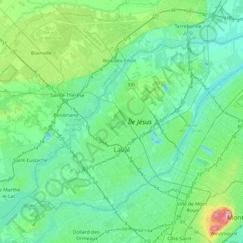
Name: Laval (administrative region) topographic map, elevation, terrain.

Location: Laval (administrative region), Quebec, Canada (45.51090 -73.89536 45.70075 -73.52350)

Average elevation: 42 m

Minimum elevation: -19 m

Maximum elevation: 229 m

Other topographic maps

Click on a map to view its topography, its elevation and its terrain.

Lac Nadine

Canada > Quebec > Sept-Rivières > Port-Cartier

Average elevation: 114 m

Luskville

Canada > Quebec > Les Collines-de-l'Outaouais > Pontiac

Average elevation: 131 m

Lac Manitou

Canada > Quebec > Minganie > Havre-Saint-Pierre

Average elevation: 131 m

Sommet

Canada > Quebec > Deux-Montagnes (MRC) > Oka

Average elevation: 62 m

Lévis

Canada > Quebec > Lévis

Average elevation: 90 m

Manicouagan

Canada > Quebec

Average elevation: 496 m

Lac Chausson

Canada > Quebec > Passes-Dangereuses

Average elevation: 262 m