
Make a donation
Gear up for your next adventure:
As an Amazon Associate, this site earns from qualifying purchases at no extra cost to you.
Leverkusen topographic map
Click on the map to display elevation.
Make a donation
Gear up for your next adventure:
As an Amazon Associate, this site earns from qualifying purchases at no extra cost to you.
Leverkusen
Der höchste Punkt des Stadtgebiets befindet sich an der Stadtgrenze zu Burscheid in Höhe der Kompostierungsanlage Heiligeneiche mit 198,7 m ü. NHN, der niedrigste mit 35,1 m ü. NHN liegt bei der Hitdorfer Hafeneinfahrt. Die Stadtgrenze hat einen Umfang von 56 Kilometern. Die größte Nord-Süd-Ausdehnung beträgt 8,9 und die größte West-Ost-Ausdehnung 15,3 Kilometer.
Make a donation
Gear up for your next adventure:
As an Amazon Associate, this site earns from qualifying purchases at no extra cost to you.
About this map
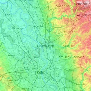
Name: Leverkusen topographic map, elevation, terrain.
Location: Leverkusen, Nordrhein-Westfalen, 51373, Deutschland (50.87247 6.82812 51.19247 7.14812)
Average elevation: 98 m
Minimum elevation: 24 m
Maximum elevation: 380 m
Make a donation
Gear up for your next adventure:
As an Amazon Associate, this site earns from qualifying purchases at no extra cost to you.