
Make a donation
Gear up for your next adventure:
As an Amazon Associate, this site earns from qualifying purchases at no extra cost to you.
Dima topographic map
Click on the map to display elevation.
Make a donation
Gear up for your next adventure:
As an Amazon Associate, this site earns from qualifying purchases at no extra cost to you.
About this map
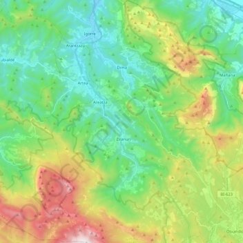
Name: Dima topographic map, elevation, terrain.
Average elevation: 501 m
Minimum elevation: 72 m
Maximum elevation: 1,478 m
Make a donation
Gear up for your next adventure:
As an Amazon Associate, this site earns from qualifying purchases at no extra cost to you.
Other topographic maps
Click on a map to view its topography, its elevation and its terrain.
Foronda
Spain > Autonomous Community of the Basque Country > Gasteizko kuadrilla/Cuadrilla de Vitoria > Vitoria-Gasteiz
Average elevation: 525 m
Biañez
Spain > Autonomous Community of the Basque Country > Karrantza Harana / Valle de Carranza > Biañez
Average elevation: 232 m